
Where Is Bohemian National Cemetery ?
Where is Bohemian National Cemetery? The answer for the post office is:
If you are a Chicagoan you might say
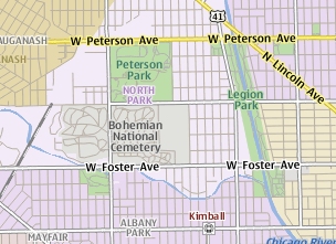
If you are telling a cabbie you might say
"52 hundred north and 40 hundred west "
If you were buying or selling land you would use the township
and range system. Before Chicago was platted the area was surveyed using the
township and range system. This area uses a N-S dividing baseline called the
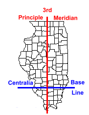 Centralia baseline and an E-W divider called the 3rd principle meridian. The
system divides the area into 6 mile squares called townships bounded by township
lines (dividing N-S ) and range lines (E-W dividers).
Centralia baseline and an E-W divider called the 3rd principle meridian. The
system divides the area into 6 mile squares called townships bounded by township
lines (dividing N-S ) and range lines (E-W dividers).
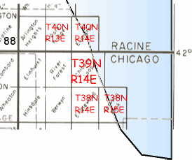
BNC is 40 townships (240mi) north of the Centralia baseline and 13 (78 mi)
east of the 3rd principle meridian so it is Township 40N, Range 13E.
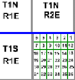
Each township is divided into 1 mile numbered squares called sections containing
640 acres. Each section is divided into quarter sections (160acres) and each
quarter may be divided into quarters (40 acres). If you hear somebody talk about
"the back 40" they are refering to one of those 1/4 of a1/4 of a section.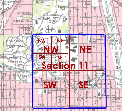
The gate of Bohemian National Cemetery is in the SW quarter of the NW quarter of section 11 in township 40 North and Range 13 East or:
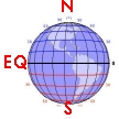
If you were talking to a navigator you might use the latitude and longitude coordinates based on the poles and the equator. BNC is 41.978 degrees north of the equator (2900 mi) and 87.728 degrees west of the Prime Meridian in Greenwich, England (6000 mi). So, BNC is
If you were talking to a GPS satellite (which has no fear
of mathematics) you might use the UTM (Universal Transverse Mercator) system.
In this system the earth is divided into 60 zones from pole to pole. Each zone
has a midline arbitrarily given the value 500,000 meters. The east - west location
is given by the meters from that line, less than 500,000 if east, and more than
500,000 if west. This number is called the Easting. The north or south is given
by the number of meters from the equator.This number is called the Northing.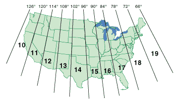
Your satellite believes BNC is in zone 16, 439687 meters relative to the 500,000 meter midline and 4647589 meters North of the equator so BNC is:
Whether any of this is an improvement on "go down the road to the big oak tree and turn left til you get to the creek", I'll leave you to decide.